
A Deep Dive Into Wetlands [Free Lesson Plan]
Each summer Tremont welcomes 2-3 Community Science Educators to join the Tremont science team. These Educators are tasked with an array of projects which include co-leading our science camps for teens, helping to run our bird banding station, engaging in data collection on butterflies to lichens to salamanders, and creating their own project to strengthen Tremont’s understanding of an area of interest related to science in the Smokies.
When you picture the environments in which these educators and campers play, learn, and explore, you may picture moss-covered rocks in freshwater rivers and creeks, blue ridge mountains, and various forests extending as far as the eye can see. Maybe you even think about the fields of Cades Cove or the high elevation Spruce Fir Forests. And you would be right! There is another ecosystem, however, that is often overlooked or not associated with mountain habitats.
Madeline Walker was one of two Community Science Educators for the summer of 2023. An avid naturalist and Environmental Science student at Maryville College, Madeline came with a special interest in an oft-unknown ecosystem present within the mountains: wetlands. As the name suggests, wetlands are areas where the land is wet! More specifically, they are areas where water is present at or near the surface of the soil either year-round or during temporary periods known as hydroperiods. While fewer than 1% of the Smokies are considered “wetlands,” they help sustain a great diversity of species within the habitats that they provide.
As part of her summer experience, Madeline dove in (figuratively!) to wetlands: what defines them, who lives there, and how they can be used as a teaching tool to understand soil, biodiversity, and hydrology (the movement and interaction of water with the land). If you want to take a deep dive into the science of these fascinating systems, you can check out this scientific write-up Madeline compiled below. Are you ready to stomp right into a wetland and explore for yourself? You can check out these exploration and discussion suggestions Madeline created for grades 6-12.
The term wetland may have a drastically different meaning to everyone depending on their own personal experiences. To some, thinking of a wetland sparks imagery of insect-laden, murky water that smells of rotting vegetation and eggs as it engulfs your leg with each step. Others may think of the tall grasses or trees that support a variety of migratory birds. Wetlands are a dynamic, critically important ecosystem full of life, history, chemistry, and beauty. There are many ways we can learn from these systems!
Due to the high diversity of wetland types and the dynamic nature of the systems themselves, defining and determining where a wetland begins and ends may vary depending on the wetland aspects of interest. For example, the definition used for legal classification and policy (U.S. Army Corps of Engineers) focuses on different aspects than the definition used for an ecological study (U.S. Fish and Wildlife Service).1 For this reason, it is easier to define a wetland based on the presence of the following characteristics: hydrologic regime (characteristic water pattern), hydric soils (saturated for 7-day minimum), and hydrophytic plants (water-tolerant vegetation).1,2,3 The presence of these characteristics can have impacts on the presence of others, and in that way they interact with each other to create unique habitats and support biodiversity.
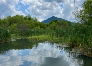
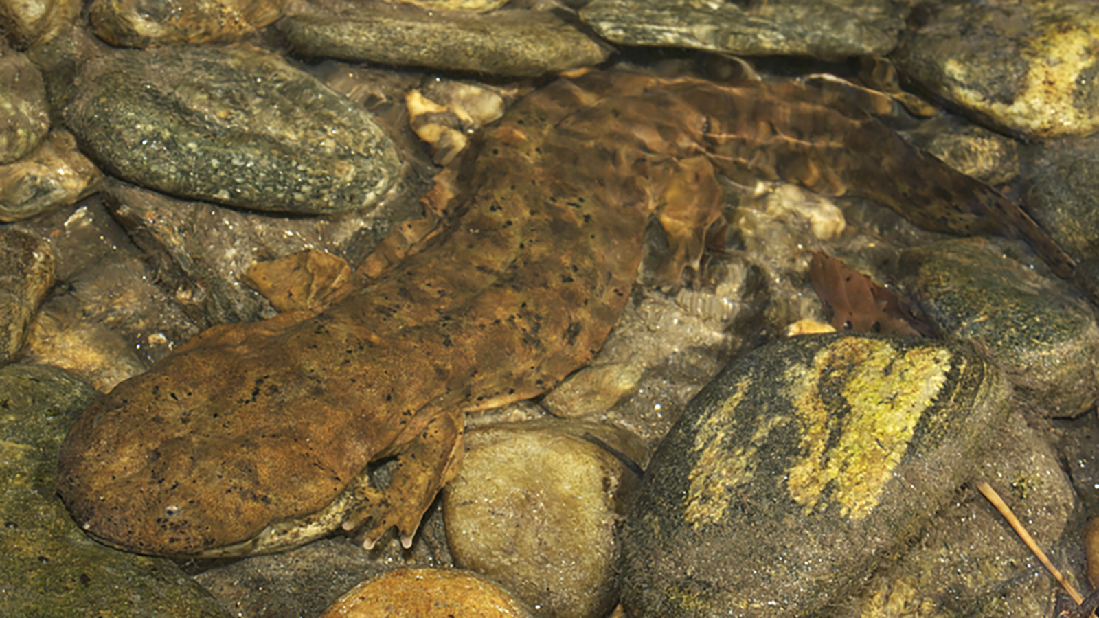
Photo by Madeline Walker
Hydrologic Regime
Hydrologic regime describes how water moves through a given space over time9. The hydrologic regime of a wetland is a defining characteristic due to the direct impact it has on the physical environment.1 Wetlands are found in areas that may accumulate water due to their positioning within the landscape. Factors such as climate, depressional topography, geography, geomorphology, and soil/ground substrates contribute to the conditions necessary to physically support a wetland.1,2,4,5 With the support of proper landscape features, water sources such as surface water, precipitation, groundwater, and/or oceanic tides may be retained.4
Each wetland, however, does not function in the same way. Each has a unique hydrologic signature in which the following characteristics may vary: 1) Timing, frequency, and duration of waterlogging, 2) The water level depth (magnitude), 3) Spatial extent, 4) Variability of parameters.9 Other factors such as the water budget (sum of water entering and exiting), residence time (how long the water is retained in the wetland), and the hydro-pattern (water level fluctuation over time) may also contribute to the hydrologic signature.1,4
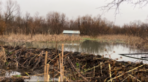
Photo by Madeline Walker
The hydrologic signature also shapes the land, chemistry, plants, and animals of the area.1,4 For example, the time and pattern an area is flooded or saturated, also known as hydroperiod, create favorable conditions for different types of vegetation in different areas of the wetland.6 The hydroperiod, therefore, contributes to the abundance, diversity, and distribution of vegetation.1,6
Here are some ways to directly observe the hydrologic regime even if water is not present:2,13
- Low depressions in the ground where water may accumulate
- Channelized structures
- Deposits of sediment and organic material on vegetation and ground from where water was previously present
- Wet, muddy, or spongy ground
- Mud with cracks on the surface
- Water staining on tree trunks
Hydric Soil
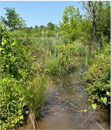
Photo by Madeline Walker
A hydric soil is defined by the United States Department of Agriculture as “a soil that formed under conditions of saturation, flooding, or ponding long enough during the growing season to develop anaerobic conditions in the upper part.”7,8 The saturated soils and absence of oxygen in the upper part of the soil may result in a slower decomposition process of organic material, as oxygen is required by the organisms that break down this material.1,10 Wetlands are known to have high primary production, so as this vegetation dies, the organic material in the forms of moss, herbaceous litter, and wood/leaf litter may accumulate.1 As organic material decomposes, it may be considered peat (also referred to as “fibrist”) when it is less than one-third decomposed and you can still distinguish what plant the material originated from. It is considered muck (or “saprist”) when two-thirds or more of the material is decomposed, and you can no longer determine the origin of the plant material. Anything in between peat or muck may be considered mucky peat or peaty muck (hemists).1
When there is not a large presence of organic material in wetland soil, it may be considered a mineral soil. Mineral soils reflect different properties of wetland characteristics and hydrology than organic material. Due to the absence of oxygen, mineral soils may show redoximorphic features which can be visually observed. As ferric iron (Fe3+) and manganese (Mn3+ or Mn4+) in the soil become reduced in the oxygen-depleted environment, they gain hydrogen ions forming ferrous iron (Fe2+) and manganese (Mn2+). When iron is in the oxidized ferric (Fe3+) form, it is typically a rusty red color. When it is in the ferrous (Fe2+) form, it becomes soluble and may leave a gray or black color as it leaches out. This process is known as gleization.1, 2, 8,10,11,12
Here are some of the observable indicators of wetland soils:13,2,
- Smells like rotten eggs from hydrogen sulfide
- Saturated organic soils with possible accumulation of peat
- Water collects in hole when you dig.
- Bright red or back mottling within soil from reduced conditions, especially around root of plants
- Gray-colored mineral soils referred to as gleyic soils
Hydrophytic Vegetation
As plants create sugars out of carbon dioxide, water, and sunlight via photosynthesis, they also perform a process known as respiration to use the stored energy in the sugars to grow. To perform respiration, plants require oxygen to convert the sugars into energy (ATP). When soils are saturated (hydric), the pockets of air within the soil that usually hold oxygen are filled with water, and this makes it difficult for the roots of plants to respire. Plants adapted to saturated conditions, also known as hydrophytes, have special adaptations to withstand these anoxic environments.
Although there are several physiological, reproductive, and developmental strategies hydrophytic plants have to survive anoxic, water-variable, and toxic wetland environments, here are some commonly observable adaptations used to recognize hydrophytic plants:1, 13
-
Hypertrophied lenticels
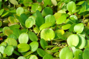
Frogs bits (Limnobium spongia)
- In times of flooding, some tree species, such as the Bald Cypress or Red Mangrove, may increase the surface area of these organs along or above the waterline to increase oxygen intake in anaerobic environment.
- Aerenchyma- hollow air-filled plant tissue to move air into stems and roots, as commonly observed in cattails
- Long tubes of air that transport oxygen to roots, as seen in many reeds, grasses, and sedges
- Stem hypertrophy- the cells at the base of the tree are larger with lower-density wood
- Pneumatophores- modified roots for respiration, such as Cypress knees
- Adventitious roots- roots that form above the soil surface when soil may become saturated long enough for other roots to die, as seen in Jewelweed, willow shrub, and green ash
- Shallow roots- adapted to anoxic environment and high-water table.
- Inflated leaves, stems, or roots with air pockets- spongy tissue allowing floating, such as Frogs bit (Limnobium spongia), pictured on right
- Floating stems, as seen in floating primrose
- Oxygen pathway roots Saltmarsh Cordgrass (Spartina alterniflora)
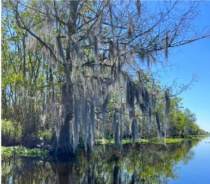
A cypress tree – depicting pneumatophores and stem hypertrophy. Photo by Madeline Walker
The physical environment of wetlands impacts the distribution of vegetation due to pressures of varying water levels, flow, anoxia, salinity, or toxicity. This is reflected by the distribution of plants with similar characteristics within various areas of the wetland environment. Emergent vegetation is commonly found in transitional areas between bodies of water and upland as they are connected to the ground yet able to withstand various flooded or saturated conditions. Floating vegetation, however, is found on the surface of shallow or deeper water due to its ability to attach to the ground, each other, or other substrates. Submerged macrophytes are adapted to be attached to the ground; however, they require larger pools of water as their growth remains underwater.
Wetland vegetation has evolved to not only live in the physical hydraulically-varying, anoxic environment (allogenic succession), but they also have adaptations that allow them to alter the ecosystem to be better suited for themselves (autogenic succession).1 For example, emergent plants are rooted to the ground in areas with possible varying water levels. As the water levels change, this vegetation can remain in this area due to dense deep roots that stabilize soils on the water’s edge. The stabilized soils allow the plant to remain within that area, which in turn supports their resistance to the hydraulic characteristics within that area.


A few birds that can benefit from wetlands. Photos by John Matthew Erickson.
Why are wetlands important?
Today’s media and some Western mindsets have been known to portray wetlands as smelly, buggy areas to avoid, convert, or control. An example of this negative connotation is reflected in commonly used phrases such as “bogged down” and “swamped with work.”1 These mindsets have contributed to past governmental support of drainage and conversions of nutrient-rich wetlands for agriculture and development.15 These practices resulted in over 50% loss of our wetlands in the lower 48 states between the 1780s and 1980s.16 Tennessee alone is estimated to have lost over 59% of its wetlands in that period.15 Today, however, the United States has recognized the importance of these systems and has protective laws in place to counteract this net loss.15 We’re beginning to realize that a properly functioning wetland’s chemical, biological, and physical characteristics provide several ecosystem services that positively impact communities.
Chemical benefits of wetlands can be seen through water quality. As water enters a wetland, it carries with it the contaminants of where it is from. As water runs over land, agricultural runoff (pesticides, herbicides, fertilizers, animal waste, sedimentation), municipal water (wastewater from communities), sediments from development, and other pollutants in stormwater runoff and groundwater are carried with it. As the contaminants of upland drain into the area, wetlands can trap pollution, heavy metals, and sediment from entering another water source. Vegetation can slow water velocities enough to allow sediments and heavy metals to fall out of the moving water to the bottom of the water system. Heavy metals and pollution may also be taken up by vegetation, reduced to less toxic forms through ion exchange, or buried in soils. Wetlands are also highly productive systems for processing waste due to high biological productivity (lots of plant growth) and bacterial activity in the sediment layers.
Excess inorganic nitrogen, such as ammonium (NH4+) and nitrate (NO3–) from fertilizers may enter a wetland from runoff (especially agricultural) or groundwater. Although inorganic forms of nitrogen are essential for plants and animals to create the organic forms of life (like DNA and proteins), having too much inorganic nitrogen in water may alter ecosystems by causing algal blooms, which in turn die off and result in loss of oxygen through decomposition. Wetlands assist in the conversion and temporary storage of nitrogen in the soils, vegetation, and dead plant material. Denitrification is also a process bacteria in anoxic conditions may perform in which inorganic nitrogen (NH4+) and (NO3–) may be returned to the atmosphere (N2).1,2,19
Wetlands can also help human communities. They are known to provide flood protection by retaining and slowly releasing water. Wetland vegetation helps slow the velocity of water, which not only reduces erosion and acts as a buffer during storms, but also allows the accumulation of sediment, cleaning water before it reaches aquifers that humans depend on..
Culturally, several human communities have lifestyles that reflect their interdependence with wetland ecosystems rather than their dominance over them. While current members of the Miccosukee Tribe in the Florida Everglades have moved away from traditional methods of building, their ancestors used wetland grasses and materials for homes, consumed fish and native plants, and traveled via canoes made from wetland trees, and their people remain connected to these ecosystems today.1,2 The Louisiana Cajun community also base much of their culture, society, and economy around crayfish, fish, and other wetland animals.1,2 Wetlands also provide peat for horticulture and energy, mangrove trees for timber, wild rice, and cranberries.1,2 Wetlands are also inherently valuable due to beauty, recreation, and ways we can learn from them.